|
Navigation
LakesnWoods.com
Home
Page
Contact Us
Privacy
Minnesota History Shop
Visit The Minnesota History Shop
www.minnesotahistoryshop.com
Historic maps
Historic books
Historic framed art
Historic
postcards
Clothing with historic
images
And much more!!! |
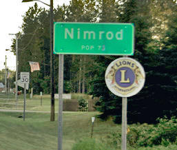
Nimrod Guide:
Photo Gallery
Location
Geography
Demographics
History
Government
Post Office
News
Weather
Street Map
Events
Attractions
Recreation
Lakes
Health Care
Schools
Churches
Media
Motels
Resorts
Campgrounds
Businesses
Aerial Photo
Topographic Map © 2004-2025
LakesnWoods LLC
All Rights Reserved
DCMA, Defamation, Copyright and Trademark Infingement Policy
|
WANTED! Do you have photos, historical accounts or
other items pertaining to the Nimrod area? Would you like to
share this historical information with the world?
LakesnWoods.com would like to publish your Nimrod photos
(current or historical) or historical accounts on this website.
Original materials can be returned and your privacy will be
respected.
Contact us |
|
Nimrod Minnesota Community Guide
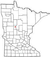
Location:
Population:
| Nimrod (city) |
1970 |
1980 |
1990 |
2000 |
2010 |
2000-2010
Change |
| Actual |
Percent |
| Population |
64 |
69 |
65 |
75 |
69 |
-6 |
-8.00 |
| Land Area (sq. mile) |
0.80 |
1.01 |
0.93 |
0.93 |
0.92 |
-0.01 |
-1.08 |
| Density (persons per sq. mile) |
80.0 |
68.3 |
69.9 |
80.7 |
75.0 |
-5.7 |
-7.06 |
| Housing Units |
36 |
39 |
43 |
47 |
49 |
+2 |
+4.26 |
| Households |
-- |
30 |
32 |
35 |
34 |
-1 |
-2.86 |
| Persons Per Household |
-- |
2.30 |
2.03 |
2.14 |
2.03 |
-0.11 |
-5.14 |
Geography:
Nimrod is a city in Wadena County,
Minnesota. Minnesota State Highway 227 has its eastern
terminus in Nimrod, having travelled 11 miles from
Sebeka, the western terminus. According to the United
States Census Bureau, the city has a total area of 0.97
square miles (2.51 km2); 0.92 square miles (2.38 km2) is
land and 0.05 square miles (0.13 km2) is water. The elevation is 1,325 ft (404 m)
above sea level.From
Wikipedia, the free encyclopedia
Demographics:
As of the census of 2010, there were
69 people, 34 households, and 19
families residing in the city. The
population density was 75.0 inhabitants
per square mile (29.0/km2). There were
49 housing units at an average density
of 53.3 per square mile (20.6/km2). The
racial makeup of the city was 100.0%
White.
There were 34 households of which
14.7% had children under the age of 18
living with them, 44.1% were married
couples living together, 8.8% had a
female householder with no husband
present, 2.9% had a male householder
with no wife present, and 44.1% were
non-families. 35.3% of all households
were made up of individuals and 14.7%
had someone living alone who was 65
years of age or older. The average
household size was 2.03 and the average
family size was 2.63.
The median age in the city was 51.8
years. 15.9% of residents were under the
age of 18; 5.8% were between the ages of
18 and 24; 20.2% were from 25 to 44;
33.2% were from 45 to 64; and 24.6% were
65 years of age or older. The gender
makeup of the city was 39.1% male and
60.9% female.
From
Wikipedia, the free encyclopedia
History:
NIMROD, a city in section 32 of Orton, is named for
the grandson of Ham, called, in Genesis, "a mighty hunter before the
Lord," who is reputed to have directed the construction of the Tower of
Babel. The city was incorporated as a village on August 20, 1924, and as
a city on December 4, 1946; the post office operated 1887-1916 and was
reestablished as a rural branch in 1938. The city became a halfway stop
for wheat haulers between Shell City and Verndale on what was called the
Wheat Trail; in 1885 Paluski Williams took over the halfway house of
Jake Graba, developing it into a hotel, where his wife, Mary L.
Williams, was the first postmaster until 1903. The village had a station
of the Great Northern Railway. Courtesy
Minnesota Historical Society
Government:
Nimrod City Hall
23314 State Highway 227
Sebeka, MN 56477
Phone: (218) 472-2489
Regular Business Hours:
not
available
City Council Meetings:
2nd Monday of the
month at 6:30 pm


 |
|
| Title |
Term Ends |
Name and
Address |
|
Phone |
| Mayor |
12/31/2022 |
Keith Frame
23388
County Road 14
Sebeka, MN 56477 |
|
(218) 472-3220 |
| Clerk |
12/31/2022 |
Karen J. Lepinski
23322 County Road 14
Sebeka, MN 56477 |
|
(218) 837-5724 |
| Treasurer |
12/31/2024 |
Patricia Frame
23388
County Road 14
Sebeka, MN 56477 |
|
(218) 472-3220 |
| Council Member |
12/31/2022 |
Coleman Rydie
23345 Acorn Street
Sebeka, MN 56477 |
|
(218) 472-5657 |
| Council Member |
12/31/2024 |
Aaron Frame
23317
Fir Street
Sebeka, MN 56477 |
|
(218) 472-3209 |
| Council Member |
12/31/2024 |
Kevin Milbradt
23445 County Road 14
Sebeka, MN 56477 |
|
(218) 472-3242 |
Post Office:
The Nimrod Post Office closed. Nimrod is now served by
the Sebeka Post Office.
Utilities:
Major
Employers:
|
Employer |
Products/Services |
Employees |
|
n/a |
News:
Weather:
Map:
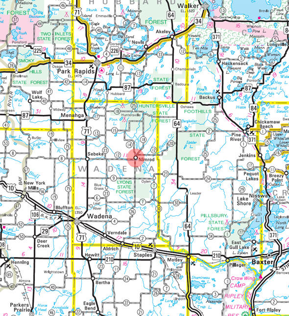
Minnesota State
Highway Map of the Nimrod Minnesota area
Events:
Attractions:
Recreation:
Lakes:
Health
Care:
Schools:
Churches:
Nimrod Lutheran
Church
28134 County Road 26
Sebeka, MN 56477
Phone: (218) 472-3306 |
|
Media:
Motels:
Resorts:
Campgrounds:
Businesses:
Nimrod Bar and Grill
23324
Nimrod Avenue
Sebeka, MN 56477
Phone: (218) 472-9203 |
|
Nimrod Community
Center
23276 State Highway 227
Sebeka, MN 56477
Phone: (218) 472-3405 |
|
Aerial Photo:
Topographic Map:
[click map to enlarge, zoom in or zoom out]
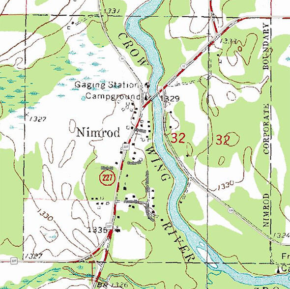 Topographic map is courtesy of the Minnesota DNR
-
Click map to enlarge or zoom
Topographic map is courtesy of the Minnesota DNR
-
Click map to enlarge or zoom |
|