|
|
|
|
|
|
Navigation LakesnWoods.com
© 2004-2025 DCMA, Defamation, Copyright and Trademark Infingement Policy
Walleye
Fear Me Hat
|
|
||||||||||||||||||||||||||||||||||||||||||||||||||||||||||||||||||||||||||||||||||||||||||||||||||||||||||||||||||||||||||||||||||||||||||||||||||||||||||||||||||||||||||||||||||||||||||||||||||||||||||||||||||||||||||||||||||||||||||||||||||||||||||||||||
 |
| Randolph (city) | 1970 | 1980 | 1990 | 2000 | 2008 (est) |
1990-2000 Change | |
|---|---|---|---|---|---|---|---|
| Actual | Percent | ||||||
| Population | 350 | 351 | 331 | 318 | 394 | -13 | -3.93 |
| Land Area (sq. mile) | 1.00 | 1.02 | 0.99 | 0.99 | -- | 0.00 | 0.36 |
| Density (persons per sq. mile) | 350.0 | 344.1 | 334.3 | 320.1 | -- | -14.27 | -4.27 |
| Housing Units | 97 | 112 | 117 | 121 | -- | 4 | 3.42 |
| Households | -- | 110 | 111 | 117 | 143 | 6 | 5.41 |
| Persons Per Household | -- | 3.19 | 2.98 | 2.72 | 2.75 | -0.26 | -8.79 |
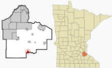
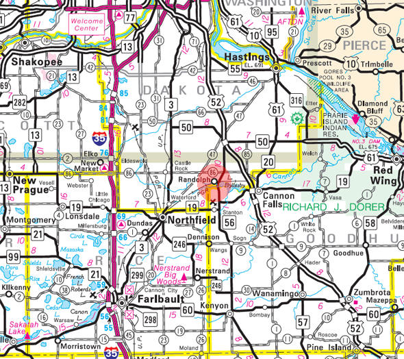
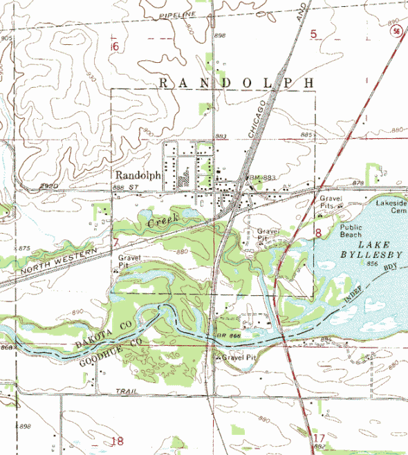
Randolph is a city in Dakota County, Minnesota. State Highway 56 serves as a main route in the community. U.S. Highway 52 and State Highway 19 are in close proximity to the city. According to the United States Census Bureau, the city has a total area of 1.0 square miles (2.7 km²), of which, 1.0 square miles (2.6 km²) of it is land and 0.04 square miles (0.1 km²) of it (3.88%) is water. The elevation is 879 ft (268 m) above sea level.
From Wikipedia, the free encyclopedia.
There were 117 households out of which 38.5% had children under the age of 18 living with them, 65.0% were married couples living together, 6.0% had a female householder with no husband present, and 23.9% were non-families. 22.2% of all households were made up of individuals and 4.3% had someone living alone who was 65 years of age or older. The average household size was 2.72 and the average family size was 3.13.
In the city the population was spread out with 28.9% under the age of 18, 6.6% from 18 to 24, 33.0% from 25 to 44, 20.4% from 45 to 64, and 11.0% who were 65 years of age or older. The median age was 35 years. For every 100 females there were 101.3 males. For every 100 females age 18 and over, there were 98.2 males.
The median income for a household in the city was $42,750, and the median income for a family was $48,125. Males had a median income of $35,375 versus $25,000 for females. The per capita income for the city was $16,947. About 3.9% of families and 4.3% of the population were below the poverty line, including none of those under age 18 and 13.5% of those age 65 or over.
Visit The
Minnesota History Shop! |
RANDOLPH Township, established April 20, 1858, was then named Richmond, "in honor of John Richmond, the first settler within its limits." This name was rejected September 18, 1858, because there was another Richmond in the state, and the township was called Wheatland until October 30, 1858, when it was renamed Randolph. "D. B. Hulburt, an admirer of the Virginia statesman, John Randolph, suggested that his distinguished surname be given to the town." This was "Randolph of Roanoke," as he was generally known, who was born in 1773 and died in 1833. The city of Randolph, in sections 5 to 8, was incorporated as a village on May 23, 1857, and again on November 15, 1904; it had a station of the Chicago Great Western Railroad, and its post office was established in 1886.
Courtesy Minnesota Historical Society
|
Randolph City Hall 4365 292nd Street East PO Box 68 Randolph, MN 55065 Phone: (507) 645-7492 Regular Business Hours: vary, call City Council Meetings: 2nd Wednesday of the month at 7:00 pm 


 |
||||
| Title | Term Ends | Name and Address | Phone: | |
| Mayor | 12/31/2022 | Robert L. Appelgren
Jr. 29252 Dixie Avenue Randolph, MN 55065 |
(507)
492-7818 (763) 406-9031 |
|
| Clerk | 12/31/2022 | Mary Haro 4353 292nd Street Randolph, MN 55065 |
|
(507) 645-4520 |
| Treasurer | 12/31/2024 | Sandra Nicolai 29072 Cynthia Path Randolph, MN 55065 |
(612) 566-4608 | |
| Council Member | 12/31/2022 | Sarah Podritz 4220 292nd Street E Randolph, MN 55065 |
(507) 249-0203 | |
| Council Member | 12/31/2024 | Jacob Friedrich 3801 292nd Street E Randolph, MN 55065 |
(612) 919-2758 | |
| Council Member | 12/31/2024 | Todd D. Carlock 29163 Daniel Avenue Randolph, MN 55065 |
(612) 708-1769 | |
|
US Post Office 4346 292nd Street E Randolph, MN 55065-9577 Phone: (507) 645-5812 Toll Free: (800) ASK-USPS |
|
||
|
|||
| Utility Type | Utility Name | Utility Phone |
| Electricity |
n/a |
-- |
| Natural Gas | n/a | -- |
| Wastewater | n/a | -- |
| Water | n/a | -- |
| Telephone | n/a | -- |
| Cable TV | n/a | -- |
| Employer | Products/Services | Employees |
|
n/a |
||
Minnesota State
Highway Map of the Randolph Minnesota area
Check Out
The Minnesota
History Shop! Good Goods and
Great Gifts! |
| Lake Name | Size (acres) |
Lake info | Lake Map | Rec Map | Topo Map |
|---|---|---|---|---|---|
|
|
|
|
|
|
|
|
|
© 2004-2025 LakesnWoods LLC All Rights Reserved |
|
|
|
||