According to the United States Census Bureau, the unorganized territory has a total area of 287.86 square miles (745.54 km˛).


 |
 |
 |
|
|
Navigation
LakesnWoods.com
© 2004-2025 DCMA, Defamation, Copyright and Trademark Infingement Policy
|
|
||||||||||||||||||||||||||||||||||||||||||||||||||||||||||||||||||||||||||||||||||||||
|
|
| Unorganized Territory of Northwest Aitkin County | 1970 | 1980 | 1990 | 2000 | 2010 | 2000-2010 Change | |
|---|---|---|---|---|---|---|---|
| Actual | Percent | ||||||
| Population | 291 | 335 | 266 | 335 | 342 | +7 | +2.09 |
| Land Area (sq. mile) | 287.10 | 303.01 | 287.74 | 287.73 | 287.73 | 0 | 0.00 |
| Density (persons per sq. mile) | 1.01 | 1.11 | 0.92 | 1.16 | 1.19 | +0.03 | +1.02 |
| Housing Units | 143 | 206 | 301 | 289 | 438 | +149 | +51.56 |
| Households | -- | 102 | 95 | 125 | n/a | n/a | n/a |
| Persons Per Household | -- | 3.28 | 2.80 | 2.68 | n/a | n/a | n/a |
Visit The
Minnesota History Shop! |
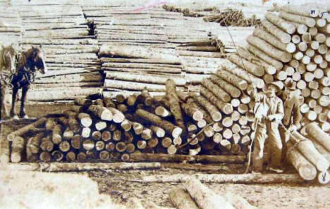
Bain Township is named in honor of William Bain, the hotel owner, who was one of the proprietors of the railway station site of the same name. The township, dissolved in 1939 and became part of Unorganized Territory of Northwest Aitkin. Bain, a settlement in Bain Township, section 26, had a post office, 1911-44.
Courtesy Minnesota Historical Society
|
|
|
None since 1939 - now part of Unorganized Territory of Northwest Aitkin County |
| None since 1944 |
|
|
|
none |
|
none |
 Lumber in Bain Minnesota, 1910s? LakesnWoods.com Postcard and Postcard Image Collection - click to enlarge |
|
none |
| none in the immediate area |
|
none |
|
none |
|
none |
|
none |
|
none |
|
none |
|
none |
|
none |
|
Topographic Map: [click map to enlarge, zoom in or zoom out]
|
|
|
|
|
© 2004-2025
LakesnWoods LLC All Rights Reserved |
|
|
|
| |||