|
|
|
|
|
|
Navigation LakesnWoods.com
© 2004-2025 DCMA, Defamation, Copyright and Trademark Infingement Policy
|
|
||||||||||||||||||||||||||||||||||||||||||||||||||||||||||||||||||||||||||||||||||||||||||||||||||||||||||||||||||||||||||||||||||||||||||||||||||||||||||||||||||||||||||||||||||||||||||||||
 |
| Brooklyn Center (city) | 1970 | 1980 | 1990 | 2000 | 2007 (est) |
1990-2000 Change | |
|---|---|---|---|---|---|---|---|
| Actual | Percent | ||||||
| Population | 35,173 | 31,230 | 28,887 | 29,172 | 27,907 | 285 | 0.99 |
| Land Area (sq. mile) | 7.90 | 8.16 | 7.95 | 7.94 | -- | -0.01 | -0.07 |
| Density (persons per sq. mile) | 4,452.28 | 3,827.21 | 3,633.58 | 3,671.98 | -- | 38.40 | 1.06 |
| Housing Units | 9,507 | 10,978 | 11,713 | 11,598 | -115 | -0.98 | |
| Households | -- | 10,751 | 11,226 | 11,430 | 11,207 | 204 | 1.82 |
| Persons Per Household | -- | 2.89 | 2.56 | 2.52 | 2.45 | -0.04 | -1.68 |
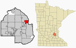
Brooklyn Center is a city in the U.S. state of Minnesota. The city lies on the west bank of the Mississippi River on the northwest border of Minneapolis in Hennepin County. Interstates 94 and 694 and Minnesota State Highways 100 and 252 are four of the main routes in the city. According to the United States Census Bureau, the city has a total area of 8.3 square miles (21.6 km²), of which, 7.9 square miles (20.6 km²) of it is land and 0.4 square miles (1.0 km²) of it (4.80%) is water. The elevation is 853 ft (260 m).
From Wikipedia, the free encyclopedia.
There were 11,430 households out of which 29.7% had children under the age of 18 living with them, 46.3% were married couples living together, 13.4% had a female householder with no husband present, and 35.4% were non-families. 28.2% of all households were made up of individuals and 11.0% had someone living alone who was 65 years of age or older. The average household size was 2.52 and the average family size was 3.11.
In the city the population was spread out with 25.1% under the age of 18, 9.6% from 18 to 24, 30.1% from 25 to 44, 19.8% from 45 to 64, and 15.4% who were 65 years of age or older. The median age was 35 years. For every 100 females there were 94.9 males. For every 100 females age 18 and over, there were 91.8 males.
The median income for a household in the city was $44,570, and the median income for a family was $52,006. Males had a median income of $36,031 versus $27,755 for females. The per capita income for the city was $19,695. About 4.7% of families and 7.4% of the population were below the poverty line, including 10.7% of those under age 18 and 5.6% of those age 65 or over.
Visit The
Minnesota History Shop! |
BROOKLYN CENTER is a city created in January 1911 and incorporated as a village February 18, 1911, from part of southeastern Brooklyn Township and eastern Crystal Lake Township. It developed first as a truck garden area, gradually becoming a residential suburb; much of the city was originally the Earle Brown farm, which was deeded to the city on his death in 1969; Brown had been sheriff of Hennepin County and chief of the Minnesota State Patrol.
Courtesy Minnesota Historical Society
|
Brooklyn Center City Hall 6301 Shingle Creek Parkway Brooklyn Center, MN 55430 Phone: (763) 569-3300 

 
 |
||||
| Title | Term Ends | Name and Address | Phone | |
| Mayor | 12/31/2022 |
Mike Elliott 6800 Lee Avenue N Brooklyn Center, MN 55430 |
|
(612) 460-1765 (763) 569-3449 |
| City Manager | appointed | Curt Boganey 6301 Shingle Creek Parkway Brooklyn Center, MN 55430 |
|
(763) 569-3300 |
| Council Member | 12/31/2024 |
Marquita Butler 3701 54th Avenue N Brooklyn Center, MN 55429 |
|
(763) 350-9753 (763) 569-3446 |
| Council Member | 12/31/2024 |
Kris Lawrence-Anderson 5213 Eleanor Lane Brooklyn Center, MN 55430 |
|
(612) 801-0770 (763) 569-3444 |
| Council Member | 12/31/2022 | Dan
Ryan 6442 Indiana Avenue North Brooklyn Center, MN 55429 |
|
(763)
535-4177 (763) 569-3445 |
| Council Member | 12/31/2022 |
April Graves 6136 Brooklyn Boulevard Brooklyn Center, MN 55429 |
|
(763) 561-0413 (763) 569-3448 |
|
US Post Office 6848 Lee Avenue N Brooklyn Center, MN 55429 Phone: (763) 561-3995 Toll Free: (800) ASK-USPS Fax: (763) 566-0961 Web: www.usps.com |
|||
|
|||
| Utility Type | Utility Name | Utility Phone |
| Electricity | Xcel Energy | (800) 642-6066 |
| Natural Gas | Minnegasco | (800) 269-1114 |
| Wastewater | Metropolitan Council Environmental Svc | (612) 222-8423 |
| Water | Brooklyn Center Municipal | (612) 569-3300 |
| Telephone | CenturyLink Communications | (800) 603-6000 |
| Cable TV | King Videocable | n/a |
| Employer | Products/Services | Employees |
|
n/a |
||
|
|

Minnesota State
Highway Map of the Brooklyn Center Minnesota area
Official City of Brooklyn Center Map [pdf]
Check Out
The Minnesota
History Shop! Good Goods and
Great Gifts! |
| Lake Name | Size (acres) |
Lake info | Lake Map | Rec Map | Topo Map |
|---|---|---|---|---|---|
|
|
|
|
|
|
|
|
|
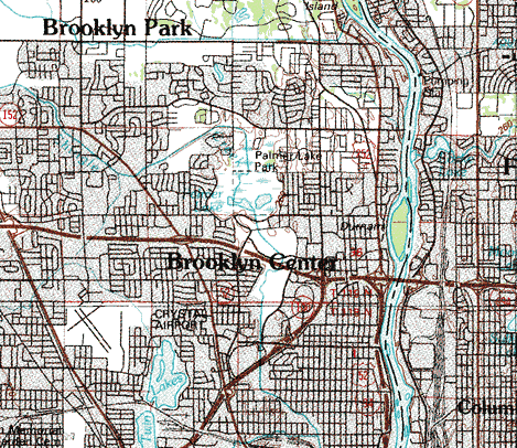
Topographic map is courtesy of the Minnesota DNR - click map to zoom or enlarge
|
|
|
|
© 2004-2025 LakesnWoods LLC All Rights Reserved |
|
|
|
||