|
|
|
|
|
|
Navigation
LakesnWoods.com
© 2004-2025 DCMA, Defamation, Copyright and Trademark Infingement Policy
|
|
|||||||||||||||||||||||||||||||||||||||||||||||||||||||||||||||||||||||||||||||||||||||||||||||||||||||||||||||||||||||||||||||||||||||||||||||||||||||||||||||||||||||||||||||||||||||||||||||||||||||||||||||||||||||||||||
 |
|
| Riverton (city) | 1970 | 1980 | 1990 | 2000 | 2010 | 2000-2010 Change | |
|---|---|---|---|---|---|---|---|
| Actual | Percent | ||||||
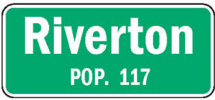
| Population | 103 | 112 | 122 | 115 | 117 | +2 | +1.74 |
| Land Area (sq. mile) | -- | -- | -- | 0.79 | 0.79 | 0 | 0.00 |
| Density (persons per sq. mile) | -- | -- | -- | 146.48 | 148.10 | +1.62 | +1.74 |
| Housing Units | -- | -- | -- | 61 | 61 | 0 | 0.00 |
| Households | -- | -- | -- | 51 | 48 | -3 | -5.88 |
| Persons Per Household | -- | -- | -- | 2.25 | 2.44 | +0.19 | +8.44 |
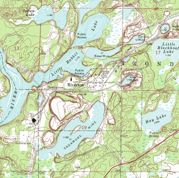
Riverton is a city in Crow Wing County, Minnesota. Riverton is located between Brainerd and Ironton, where the Mississippi River flows past the western end of the Cuyuna Range. Minnesota State Highway 210 serves as a main route in the community. According to the United States Census Bureau, the city has a total area of 0.85 square miles (2.20 km2), of which 0.77 square miles (1.99 km2) is land and 0.08 square miles (0.21 km2) is water. The elevation is 1,230 ft (375 m) above sea level.
From Wikipedia, the free encyclopedia.
As of the census of 2010, there were 117 people, 48 households, and 30 families residing in the city. The population density was 151.9 inhabitants per square mile (58.6/km2). There were 61 housing units at an average density of 79.2 per square mile (30.6/km2). The racial makeup of the city was 98.3% White and 1.7% Native American. Hispanic or Latino of any race were 0.9% of the population.
There were 48 households of which 31.3% had children under the age of 18 living with them, 47.9% were married couples living together, 10.4% had a female householder with no husband present, 4.2% had a male householder with no wife present, and 37.5% were non-families. 31.3% of all households were made up of individuals and 4.2% had someone living alone who was 65 years of age or older. The average household size was 2.44 and the average family size was 3.03.
The median age in the city was 42.2 years. 24.8% of residents were under the age of 18; 8.5% were between the ages of 18 and 24; 22.2% were from 25 to 44; 30.8% were from 45 to 64; and 13.7% were 65 years of age or older. The gender makeup of the city was 50.4% male and 49.6% female.
Visit The
Minnesota History Shop! |
In 1855, the Rabbit Lake Indian Reservation for the Rabbit Lake Band of Mississippi Chippewa was established in the area by the Treaty of Washington also known as the Treaty with the Chippewa (10 Stat. 1165). Soon afterwards, a village of Ojibway (or Ogibeway) was established at the mouth of Rabbit River. However, maps from the 1860s depict the village of Ojibway instead located either at the mouth of the Cedar River or at the mouth of the Ripple River.
Riverton was incorporated in 1912. A post office called Riverton was established in 1913, and remained in operation until it was discontinued in 1965. The city was named from its location near the Rabbit River.
From Wikipedia, the free encyclopedia.
Courtesy Minnesota Historical Society
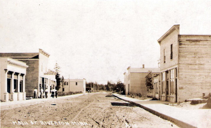
Main Street,
Riverton Minnesota,
1910s
LakesnWoods.com Postcard and Postcard Image Collection - click to enlarge
Visit The Riverton Photo Gallery for more recent and historic area photos
| Riverton City Hall 16663 Main Street Riverton, MN 56455 Phone: (218) 546-5225 Regular Business Hours:
|
||||
| Title | Term Ends | Name and Address | Phone | |
| Mayor | 12/31/2022 | David C. Peterson 21047 1st Avenue Riverton, MN 56455 |
(218) 546-6929 | |
| Clerk/Treasurer | appointed |
Alexandra Booth 16663 Main Street Riverton, MN 56455 |
 |
(218) 546-5225 |
| Council Member | 12/31/2022 | Denise Frahm 21126 2nd Avenue Riverton, MN 56455 |
(218) 772-0202 | |
| Council Member | 12/31/2022 | Lana Schmidt 16766 4th Street Riverton, MN 56455 |
(218) 251-2075 | |
| Council Member | 12/31/2024 | Ila Rae Martin 21159 Lake Avenue Riverton, MN 56455 |
(218) 546-6602 | |
| Council Member | 12/31/2024 | Pamela L. Dobson 16621 1st Street Riverton, MN 56455 |
(218) 546-8006 | |
|
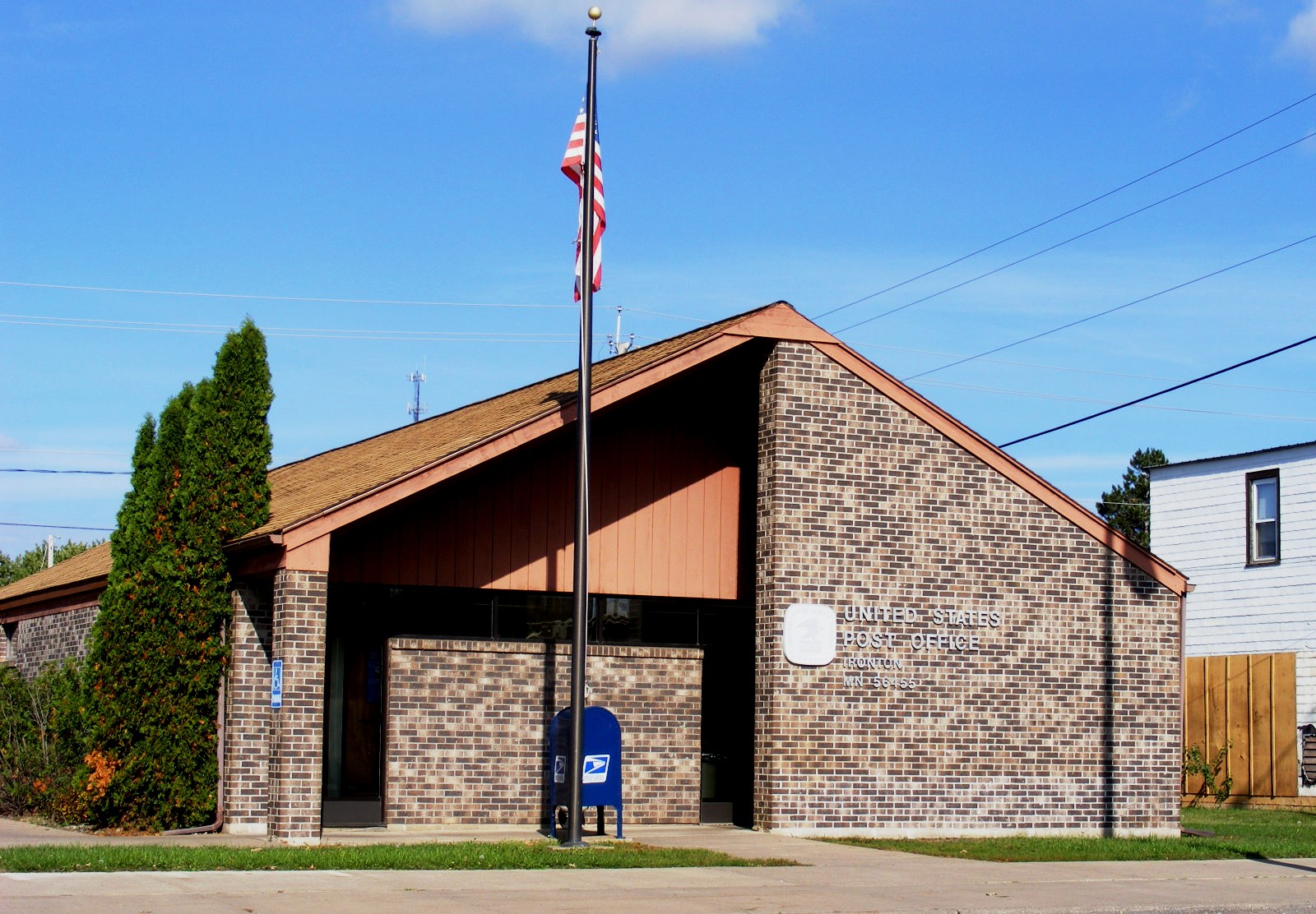
US
Post Office 115 4th Street Ironton, MN 56455-2180 Phone: (218) 546-5467 Toll Free: (800) ASK-USPS
Regular Business Hours:  
|
|
| Utility Type | Utility Name | Utility Phone |
| Electricity | Minnesota Power | (218) 546-5172 |
| Natural Gas | n/a | -- |
| Wastewater | n/a | -- |
| Water | n/a | -- |
| Telephone | CenturyLink | (888) 723-8010 |
| Cable TV | n/a | -- |
| Employer | Products/Services | Employees |
|
n/a |
||
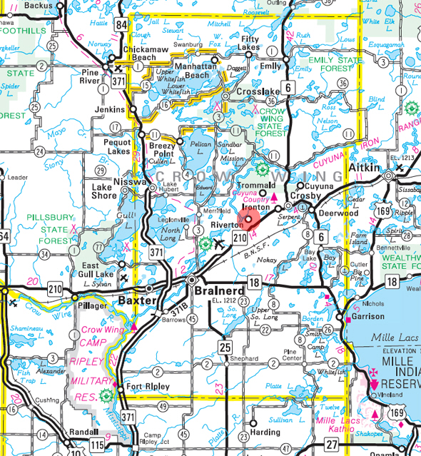
Minnesota State
Highway Map of the Riverton Minnesota area
|
none |
Check Out
The Minnesota
History Shop! Good Goods and
Great Gifts! |
|
none |
|
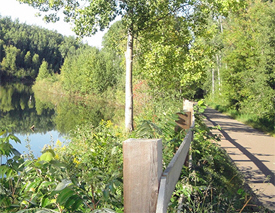
Cuyuna Trail The Cuyuna Lakes State Trail is eight miles of paved trail within the Cuyuna Country State Recreation Area from Crosby to Riverton. One mile passes through the City of Aitkin along State Highway 169. Abandoned by mining companies more than 35 years ago, the state recreation area contains six natural lakes, plus an additional 15 deep lakes that were former mine pits. Stop to fish, explore the Croft Mine, or ride the new 25-mile single track mountain bike trail system. |
 |
| Lake Name | Size (acres) |
Lake info | Lake Map | Rec Map | Topo Map |
|---|---|---|---|---|---|
| Fawn | 121 |
|
|
|
|
| Hay | 52 |
|
|
|
|
| Little Black Hoof | 72 |
|
|
|
|
| Little Rabbit | 172 |
|
|
|
|
| Mallen Pit | 6 |
|
|
||
| Portage | 76 |
|
|
|
|
| Roe Mine | 25 |
|
|
|
|
| Sagamore Mine | 119 |
|
|
||
| Snoshoe Mine | 7 |
|
|
||
| Spruce | 39 |
|
|
|
students attend school in the Crosby Ironton school district |
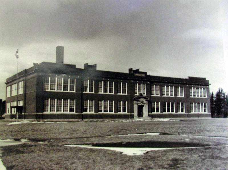 Roosevelt School, Riverton Minnesota, c1920 Operated as a school from 1916 through 1975, torn down in 2003 Courtesy Whiteley Creek Homestead - click image to enlarge |
|
none |
|
none |
|
none |
|
none |
|
none |
|
|
|
|
|||
|
|
© 2004-2025 LakesnWoods LLC All Rights Reserved |
|
|
|
|
|||