

 |
 |
 |
|
|
Navigation LakesnWoods.com
© 2004-2025 DCMA, Defamation, Copyright and Trademark Infingement Policy
|
|
|||||||||||||||||||||||||||||||||||||||||||||||||||||||||||||||||||||||||||||||||||||||||||||||||||||||||||||||||||||||||||||||||||||||||||||||||||||||||||||||||||||||||||||||||||||||||||||||||||||||||||||||||||||||||||||||||||||||||||||
 |
| South St. Paul (city) | 1970 | 1980 | 1990 | 2000 | 2008 (est) |
1990-2000 Change | |
|---|---|---|---|---|---|---|---|
| Actual | Percent | ||||||
| Population | 25,016 | 21,235 | 20,197 | 20,167 | 20,250 | -30 | -0.15 |
| Land Area (sq. mile) | 5.40 | 5.91 | 5.73 | 5.74 | -- | 0.01 | 0.10 |
| Density (persons per sq. mile) | 4,632.6 | 3,593.1 | 3,524.8 | 3,515.9 | -- | -8.88 | -0.25 |
| Housing Units | 7,679 | 7,927 | 8,294 | 8,313 | -- | 19 | 0.23 |
| Households | -- | 7,748 | 7,914 | 8,123 | 8,266 | 209 | 2.64 |
| Persons Per Household | -- | 2.72 | 2.53 | 2.47 | 2.41 | -0.06 | -2.49 |
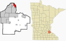
South St. Paul is a city in Dakota County, Minnesota, immediately south and southeast of the city of Saint Paul, Minnesota. Interstate Highway 494, U.S. Highway 52, and Minnesota Highway 156 are three of the main routes in the city. According to the United States Census Bureau, the city has a total area of 6.1 square miles (15.9 km≤), of which, 5.7 square miles (14.9 km≤) of it is land and 0.4 square miles (1.0 km≤) of it (6.51%) is water. The elevation is 719 ft (219 m) above sea level.
From Wikipedia, the free encyclopedia.
There were 8,123 households out of which 32.5% had children under the age of 18 living with them, 47.0% were married couples living together, 13.1% had a female householder with no husband present, and 35.3% were non-families. 28.8% of all households were made up of individuals and 10.8% had someone living alone who was 65 years of age or older. The average household size was 2.47 and the average family size was 3.05.
In the city the population was spread out with 25.4% under the age of 18, 9.0% from 18 to 24, 32.7% from 25 to 44, 20.1% from 45 to 64, and 12.8% who were 65 years of age or older. The median age was 35 years. For every 100 females there were 95.3 males. For every 100 females age 18 and over, there were 93.1 males.
The median income for a household in the city was $45,216, and the median income for a family was $54,119. Males had a median income of $36,466 versus $28,415 for females. The per capita income for the city was $21,396. About 4.1% of families and 6.1% of the population were below the poverty line, including 6.8% of those under age 18 and 5.7% of those age 65 or over.
Visit The
Minnesota History Shop! |
Courtesy Minnesota Historical Society
|
|
South St. Paul City Hall 125 3rd Avenue North South St. Paul, MN 55075 Phone: (651) 554-3200 Fax: (651) 554-3201 Regular Business Hours: Monday - Friday 8:00 am - 4:30 pm City Council Meetings: 1st and 3rd Monday of the month at 7:00 pm 


 |
||||
| Title | Term Ends | Name and Address | Phone | |
| Mayor | 12/31/2022 |
James Francis 348 6th Avenue N South St. Paul, MN 55075 |
 |
(651)
321-8348 (651) 451-0861 |
| City Administrator | appointed |
Joel Hanson 125 3rd Avenue North South St. Paul, MN 55075 |
 |
(651) 554-3272 |
| Council Member | 12/31/2022 |
Sharon Dewey 228 2nd Avenue S South St. Paul, MN 55075 |
  |
(763) 645-9168 |
| Council Member | 12/31/2022 |
Joe Kaliszewksi 256 6th Avenue S South St. Paul, MN 55075 |
 |
(651) 451-3218 |
| Council Member | 12/31/2022 |
Tom Q. Seaberg 700 Wentworth Avenue South St. Paul, MN 55075 |
 |
(651)
376-9706 (651) 999-9784 |
| Council Member | 12/31/2024 |
Lori Hansen 1121 6th Avenue S South St. Paul, MN 55075 |
 |
(651) 450-6729 |
| Council Member | 12/31/2024 |
Pam Bakken 337 Grand Avenue W South St. Paul, MN 55075 |
  |
(651) 274-2409 |
| Council Member | 12/31/2024 |
Todd Podgorski 651 15th Avenue N South St. Paul, MN 55075 |
 |
(651) 330-0584 |
|
US Post Office 236 Concord Exchange N South Saint Paul, MN 55075-1103 Phone: (651) 450-7548 Toll Free: (800) ASK-USPS Fax: (651) 552-1756   |
|
||
|
|||
| Utility Type | Utility Name | Utility Phone |
| Electricity | Xcel Energy | (800) 642-6066 |
| Natural Gas | Xcel Energy | (800) 642-6066 |
| Wastewater | Metropolitan Council Environmental Srvc | (651) 602-1005 |
| Water | South St. Paul Water Dept | (651) 450-3209 |
| Telephone | CenturyLink Communications | (800) 244-1111 |
| Cable TV | Comcast | (800) 266-2278 |
| Employer | Products/Services | Employees |
| Sportsman's Guide | Mail-Order Houses | 800 |
| South St Paul School District #6 | Elementary & Secondary Schools | 450 |
| Waterous Co | Pump & Pumping Equip. Mfg. | 375 |
| Dakota Premium Foods | Meat Processed from Carcasses | 280 |
| Stockyards Meat Packing Co. | Meat & Meat Prod. Merch. Whole. | 156 |
| American Bottling | Soft Drink Mfg. | 150 |
| Twin City Bagels | Comm. Bakeries | 150 |
| Wipaire | Other Aircraft Parts & Auxiliary Equip. Mfg. | 140 |
| Allstate Sales Corp | Truck, Utility Trailer, & RV (Recreational Vehicle) Rental & Leas | 115 |
| South Saint Paul, City of | Executive & Legislative Offices, Combined | 100 |
| Cherokee Manufacturing | Flower, Nursery Stock, & Florists' Supplies Merch. Whole. | 80 |
| Digital Angel | Communications Equipment Manufacturing | 80 |
| 20/20 Promotions | Advertising & Related Services | 75 |
| Mathias Die | Special Die & Tool, Die Set, Jig, & Fixture Mfg. | 70 |
| Holtkoetter International | Electric Lighting Equipment Manufacturing | 55 |

Minnesota State
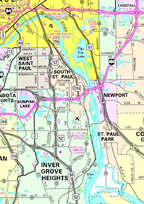
Highway Map of the South St. Paul, Minnesota area
Check Out
The Minnesota
History Shop! Good Goods and
Great Gifts! |
| Local | |
| Metro | |
|
see the Twin Cities Media Guide page for Twin Cities metro area newspapers, radio and TV |
|
|
|
|
|
|
|
© 2004-2025 LakesnWoods LLC All Rights Reserved |
|
|
|
||