|
Navigation
LakesnWoods.com
Home
Page
Contact Us
Privacy
Minnesota History Shop
Visit The Minnesota History Shop
www.minnesotahistoryshop.com
Historic maps
Historic books
Historic framed art
Historic
postcards
Clothing with historic
images
And much more!!! |
Illgen City Guide:
Photo Gallery
Location
Geography
Demographics
History
Government
Post Office
News
Street Map
Events
Attractions
Recreation
Lakes
Health Care
Schools
Churches
Media
Motels
Resorts
Campgrounds
Businesses
Aerial Photo
Topographic Map
Nearby Communities
Beaver Bay
Ely
Finland
Grand
Marais
Hovland
Isabella
Little
Marais
Lax Lake
Lutsen
Schroeder
Silver Bay
Tofte
Two Harbors Đ 2004-2025
LakesnWoods LLC
All Rights Reserved
DCMA, Defamation, Copyright and Trademark Infingement Policy
|
WANTED! Do you have photos, historical accounts or
other items pertaining to the Illgen City area? Would you like to
share this historical information with the world?
LakesnWoods.com would like to publish your Illgen City photos
(current or historical) or historical accounts on this website.
Original materials can be returned and your privacy will be
respected.
Contact us |
|
Illgen City Minnesota Community Guide
Location:
Population: Illgen
City is an unincorporated community in Beaver Bay Township
| Beaver Bay Township |
1970 |
1980 |
1990 |
2000 |
2010 |
2000-2010
Change |
| Actual |
Percent |
| Population |
905 |
1,066 |
511 |
582 |
473 |
-109 |
-18.73 |
| Land Area (sq. mile) |
294.20 |
289.66 |
138.48 |
138.56 |
138.56 |
0 |
0.00 |
| Density (persons per sq. mile) |
3.08 |
3.68 |
3.69 |
4.20 |
3.41 |
-0.79 |
-18.73 |
| Housing Units |
341 |
426 |
371 |
403 |
419 |
+16 |
+3.97 |
| Households |
-- |
292 |
198 |
242 |
213 |
-29 |
-11.98 |
| Persons Per Household |
-- |
3.02 |
2.58 |
2.33 |
2.22 |
-0.11 |
-4.72 |
Geography:
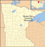
Illgen City is an unincorporated community in Beaver Bay Township,
Lake County, Minnesota. The community is located northeast of the city
of Silver Bay at the junction of Minnesota Highway 61 and Minnesota
Highway 1, on the North Shore of Lake Superior. Tettegouche State Park,
the Baptism River, and the Palisade Head rock formation are all nearby.
Beaver Bay Township is a township in Lake County,
Minnesota on Lake Superior. State Highways 1 and 61 are two of the main
arterial routes in the township. According to the United States Census
Bureau, the township has a total area of 140.2 square miles (363.1 kmē),
of which, 138.6 square miles (358.9 kmē) of it is land and 1.6 square
miles (4.2 kmē) of it (1.16%) is water. The elevation is 1,588 ft
(484 m). From
Wikipedia, the free encyclopedia
Demographics:
As of the census of 2000,
there were 582 people, 242 households,
and 163 families residing in the
township. The population density was 4.2
people per square mile (1.6/kmē). There
were 403 housing units at an average
density of 2.9/sq mi (1.1/kmē). The
racial makeup of the township was 97.77%
White, 0.17% African American, 0.34%
Native American, 0.17% Asian, and 1.55%
from two or more races. Hispanic or
Latino of any race were 0.17% of the
population.
There were 242
households out of which 20.2% had
children under the age of 18 living with
them, 64.5% were married couples living
together, 1.7% had a female householder
with no husband present, and 32.6% were
non-families. 26.9% of all households
were made up of individuals and 10.7%
had someone living alone who was 65
years of age or older. The average
household size was 2.33 and the average
family size was 2.79. In the township the
population was spread out with 21.5%
under the age of 18, 5.3% from 18 to 24,
22.3% from 25 to 44, 31.1% from 45 to
64, and 19.8% who were 65 years of age
or older. The median age was 45 years.
For every 100 females there were 104.9
males. For every 100 females age 18 and
over, there were 102.2 males.
The median income for
a household in the township was $43,438,
and the median income for a family was
$49,063. Males had a median income of
$42,222 versus $25,625 for females. The
per capita income for the township was
$19,188. About 4.1% of families and 6.2%
of the population were below the poverty
line, including 5.3% of those under age
18 and 3.1% of those age 65 or over.
History:
Illgen City has been typified by a well known sign on Highway 61 which
says "Illgen City population 4, room for lots more." Illgen City was
named for the Illgen family who settled the area in 1924. When the new
Highway 61 opened in January 1925, the family built the Aztec Hotel. The
hotel was about 70 x 70, and built in the style of the Mayan Indians
from Ucatan, Mexico. The hotel had twelve rooms upstairs, a large lobby,
dining area and bar on the main floor. There was no electricity until
1937, so they had their own light plant. There was no refrigeration, so
they cut their ice at the mouth of the Baptism River. The Aztec Hotel
was the halfway stop for people traveling the North Shore from Duluth to
Grand Marais and Canada, for thirty years. Unfortunately, the Aztec
Hotel no longer exists.
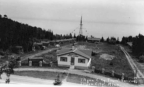
Illgen City Travel Service, 1935
Courtesy Minnesota Historical Society
Visit The Illgen City
Photo Gallery for more recent and historic area photos
Government:
Illgen City is unincorporated and located in Beaver Bay Township
Post Office: Illgen City is served
by the Silver Bay Minnesota
Post Office
Utilities:
Major
Employers:
|
Employer |
Products/Services |
Employees |
|
n/a |
News:
Weather:
Map:
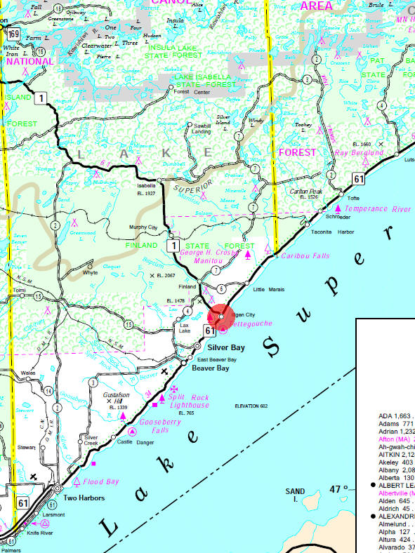
Minnesota State
Highway Map of the Illgen City Minnesota area
Events:
Attractions:
|
Lake Superior Scenic Drive |
Highway 61 |
 The
North Shore of Lake Superior, the world's largest freshwater
lake, is 154 miles of scenic beauty and natural wonders. The
drive along the lakeshore is rich with the history of American
Indians, French and British explorers, lumbering and iron ore
mining. On one side of the highway, Superior National Forest,
one of the great wilderness areas of the U.S., carpets the hills
of the Sawtooth Mountains with balsams, birch and pine. On the
other side, Lake Superior offers spectacular views from the
rocky shore. Whether it is a wilderness expedition or the
comforts of a modern lodge, the lofty pines of the Superior
National Forest and crashing waves of Lake Superior seem to have
a magic that whispers to travelers . . . "come back." The
North Shore of Lake Superior, the world's largest freshwater
lake, is 154 miles of scenic beauty and natural wonders. The
drive along the lakeshore is rich with the history of American
Indians, French and British explorers, lumbering and iron ore
mining. On one side of the highway, Superior National Forest,
one of the great wilderness areas of the U.S., carpets the hills
of the Sawtooth Mountains with balsams, birch and pine. On the
other side, Lake Superior offers spectacular views from the
rocky shore. Whether it is a wilderness expedition or the
comforts of a modern lodge, the lofty pines of the Superior
National Forest and crashing waves of Lake Superior seem to have
a magic that whispers to travelers . . . "come back." |
Recreation:
|
Tettegouche State
Park Come to Tettegouche for a
great sense of the North Shore: the spectacular overlooks at
Shovel Point; rocky, steep cliffs and inland bluffs; the
cascading 60 ft. High Falls of the Baptism River; and the
historic Tettegouche Camp where visitors can stay the night.
This is a hiker's paradise with miles of trails that overlook
the Sawtooth Mountains and wind down to inland lakes accessible
only by foot. The Palisade Valley Unit features broad scenic
vistas coupled with an expanse of multi-use, four-season trails.
Two more trout lakes complement the fishing opportunities within
the rest of the park. The park is also known for rock climbing
opportunities and quality birdwatching in the spring, summer,
and especially the fall. |
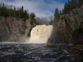
Baptism Falls in Tettegouche State Park, 2005 |
Lakes:
|
Lake Name |
Size
(acres) |
Lake info |
Lake Map |
Rec Map |
Topo Map |
| Lax |
293 |
 |
 |
 |
 |
| Micmac |
137 |
 |
 |
 |
 |
| Nicado |
13 |
 |
 |
 |
 |
|
Tetagouche |
66 |
 |
 |
 |
 |
Health
Care:
Schools:
Churches:
Media:
Motels:
Businesses:
Aerial Photo:
Topographic Map:
[click map to enlarge, zoom in or zoom out]
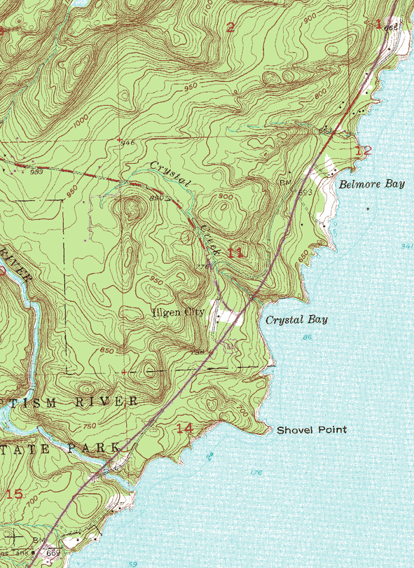 Topographic map is courtesy of the Minnesota DNR
- click map to zoom or enlarge
|
|





 The
North Shore of Lake Superior, the world's largest freshwater
lake, is 154 miles of scenic beauty and natural wonders. The
drive along the lakeshore is rich with the history of American
Indians, French and British explorers, lumbering and iron ore
mining. On one side of the highway, Superior National Forest,
one of the great wilderness areas of the U.S., carpets the hills
of the Sawtooth Mountains with balsams, birch and pine. On the
other side, Lake Superior offers spectacular views from the
rocky shore. Whether it is a wilderness expedition or the
comforts of a modern lodge, the lofty pines of the Superior
National Forest and crashing waves of Lake Superior seem to have
a magic that whispers to travelers . . . "come back."
